
@scarlett_sThe 50 drunkest counties in the United States
Voir la publication d'origine@scarlett_sThe 50 drunkest counties in the United States
Voir la publication d'originePhoto de @scarlett_s· Aug 19, 2026· United States
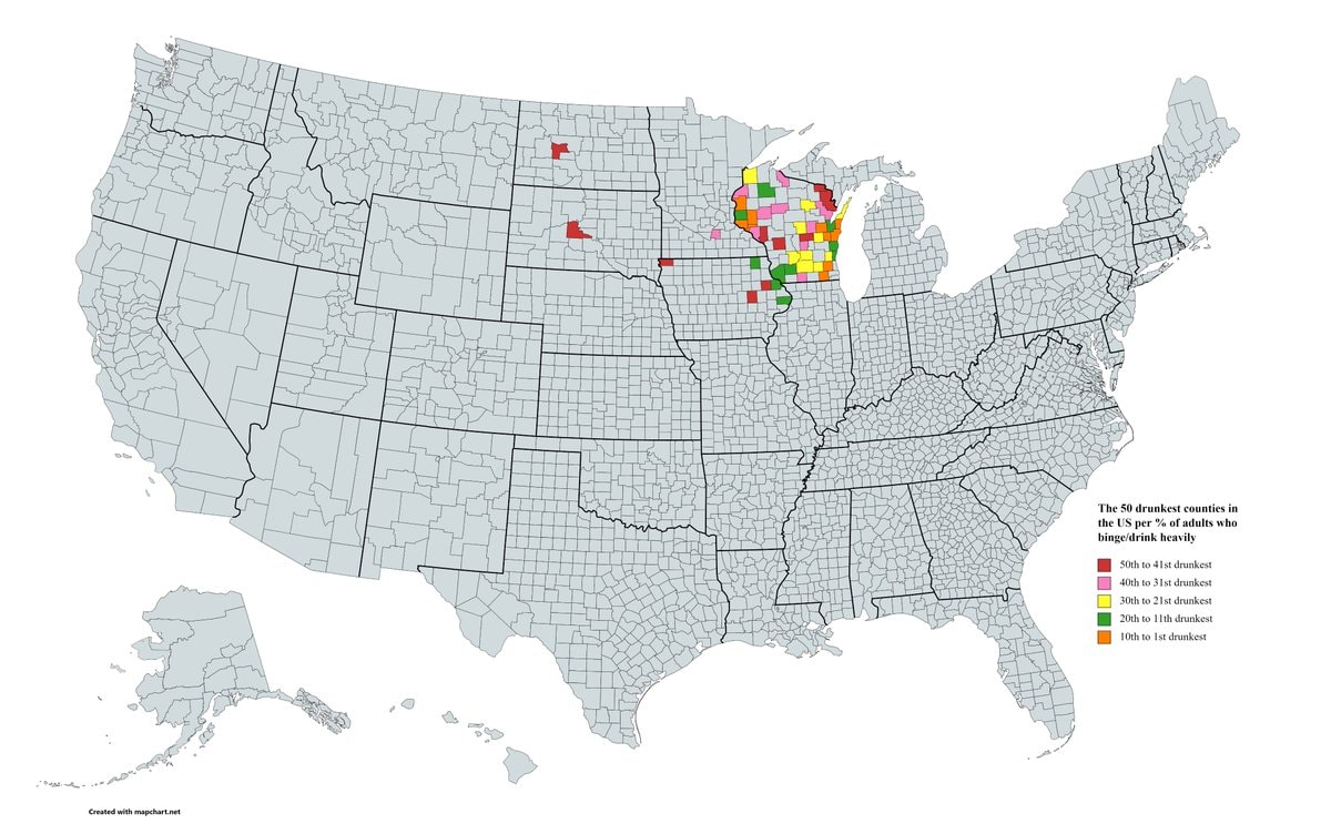
The image is a map of the United States showing county-level data. The focus is on the 50 drunkest counties based on the percentage of adults who binge or drink heavily. The map uses a color-coded legend to indicate the ranking of these counties. The mood is informative and data-driven, presented in a clean, cartographic style. Visually notable are the clusters of colored counties in Wisconsin and surrounding states, indicating higher concentrations of heavy drinkers. The legend text reads: "The 50 drunkest counties in the US per % of adults who binge/drink heavily" followed by color swatches and their corresponding ranks: "50th to 41st drunkest", "40th to 31st drunkest", "30th to 21st drunkest", "20th to 11th drunkest", and "10th to 1st drunkest". A watermark at the bottom left reads "Created with mapchart.net".
@scarlett_sThe 50 drunkest counties in the United States
Voir la publication d'originePhoto de @scarlett_s· Aug 19, 2026· United States
The image is a map of the United States showing county-level data. The focus is on the 50 drunkest counties based on the percentage of adults who binge or drink heavily. The map uses a color-coded legend to indicate the ranking of these counties. The mood is informative and data-driven, presented in a clean, cartographic style. Visually notable are the clusters of colored counties in Wisconsin and surrounding states, indicating higher concentrations of heavy drinkers. The legend text reads: "The 50 drunkest counties in the US per % of adults who binge/drink heavily" followed by color swatches and their corresponding ranks: "50th to 41st drunkest", "40th to 31st drunkest", "30th to 21st drunkest", "20th to 11th drunkest", and "10th to 1st drunkest". A watermark at the bottom left reads "Created with mapchart.net".
Aucun commentaire pour le moment. Soyez le premier !
Aucun commentaire pour le moment. Soyez le premier !